
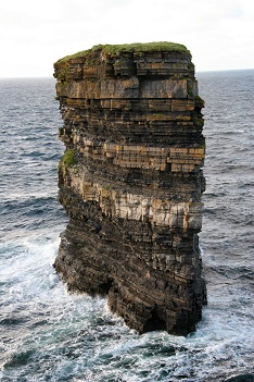
Downpatrick Head, near Ballycastle on the north coast of County Mayo, is one of the most fascinating heritage sites in Ireland. Rising to 38metres from the sea, it is a Signature Discovery Point on the Wild Atlantic Way. It is renowned for its spectacular sea stack, known as Dún Briste, ‘the broken fortress’, which broke from the mainland in 1393 in some natural cataclysm caused by the wild Atlantic waves. The sea stack, with its myriad layers of rock about 228m from the shore, once measured 63m by 23m, but further erosion has taken place in recent years. It was once the site of a promontory fort, one erected during the Iron Age, 600 BC to AD 444, with large earthen banks or stone ramparts on a natural coastal site. The headland is named after St Patrick, who is said to have founded a church there, and who is reputed to have had a big association with north Mayo. The ruin of an early church (possibly a successor of a still earlier church) can be seen there, as well as a holy well and a statue of St Patrick.
The headland was once a place of pilgrimage on Garland Sunday (the last Sunday of July). The name of the headland, in Irish Ceann Dhún Pádraig, Patrick’s headland fortress, comes from St Patrick and from the promontory fort on Dún Briste. On the east side of the headland there are the remains of a smaller promontory fort. The headland has an underground cavern with open crevices and a blow-hole with a subterranean channel to the Atlantic Ocean. A sensitive architectural and landscape installation, known as The Crossing, was erected as a safety installation there from 24 June to 4 July 2014 by Travis Price and architectural students on the Spirit of Place Programme from the Catholic University of America, Washington DC, in co-operation with local landowners and Mayo County Council. Twenty-five local people lost their lives there while hiding in the aftermath of the defeat of the French/Irish at Ballinamuck in 1798.
The location provides great views of the Atlantic Ocean and the fascinating Belderg cliffs. There is an observation hut, or lookout post, from the Second World War there, built to help guard the coast of neutral Ireland. Each such hut had a unique number, the one on Downpatrick Head being number 64. The country’s name, ÉIRE, was laid out nearby with white flagstones to warn approaching aircraft of the State’s neutrality. There are great views on the horizon from Downpatrick Head as far away as the mountains of Sligo and Donegal. The cliffs are a natural haven for wildlife, especially nesting sea birds. Visitors are warned by a notice at the carpark that they are entering at their own risk, as the area is dangerous with blow-holes, subsidence and eroding cliffs. This is in an area of great scenic beauty and interest, but extremely dangerous and should be treated with caution